Blue Ridge Parkway Points of Interest
While camping at Moonshine Creek there are many fun things to do like hiking, road biking, scenic driving, and visiting nearby waterfalls on the Blue Ridge Parkway.
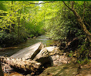
Hiking: There are some great short hikes and day hikes located within 30 minutes of the Campground.
Going towards Asheville on the Blue Ridge Parkway :
* Devils Courthouse: located at milepost 422.4. A strenuous 1/2 mile hike for a 360° view
* Graveyard Fields Overlook: located at milepost 418.8. A loop trail of moderate difficulty, 2.3 miles to Yellowstone Falls.
Going towards Cherokee on the Blue Ridge Parkway :
* Waterrock Knob: located at milepost 451.2 Waterrock Knob has an information station and a bathroom. This short hike will provide you with a 4-state view including a nice view of the Great Smoky Mountains.
* Great Smoky Mountains National Park: Milepost 469.1 Make a right at the end of the parkway and the Oconaluftee Visitor Center and Farmsteadwill be located about 1.5 miles on the right. Just past
the visitor center, the road leading to Mingus Grist Mill is located on the left. These are both very short hikes.
Road Biking:
The Blue Ridge Parkway offers some of the most scenic road bike drives in the mountains. One of the main entrances to the parkway is located just a few minutes from Moonshine Creek where you can choose to drive towards Cherokee or towards Asheville.
Scenic Drives:
The Blue Ridge Parkway offers some of the most beautiful drives in the mountains. One of the main entrances to the parkway is located just a few minutes from Moonshine Creek where you can choose to drive towards Cherokee or towards Asheville.
Waterfalls:
Waterfalls are located all along the Blue Ridge Parkway and in the Great Smoky Mountains National Park.

Things to Do On or Just off the Blue Ridge Parkway
North Carolina Arboretum, Milepost 393.6:
Located at the exit for NC 191. Stroll through a variety of gardens, on peaceful hiking trails, and don’t miss the wonderful bonsai exhibit in the greenhouse. This 426-acre public garden reflects the cultural and natural heritage of the region. Tunnels of Love: As you leave the Asheville area, you will climb quickly in elevation and go through a dozen tunnels in the next 15 miles or so.
Mt. Pisgah, Milepost 407.6:
This is a favorite hiking spot and picnic spot, but it can be a bit crowded. The hiking trail to the summit of this 5,000-foot peak is strenuous, but the reward is the view from the top. Picnic area at Milepost 407.8. Pisgah Inn, Milepost 408.7: The only inn and restaurant on this stretch of Parkway is located at 5,000 feet. It’s a great place (and very popular) to stop for lunch since their dining room has big windows with beautiful vistas. Open April through October.
Milepost 412:
US 276 crosses. Go south to the Pisgah National Forest, Cradle of Forestry (4 miles), Sliding Rock (8 miles) and Brevard (18 miles). Head north to Waynesville (22 miles). This area (Wagon Road Gap) is home to monarch butterfly migration in middle September to early October each year.
The Cradle of Forestry in America
is a 6,500 acre Historic Site within the Pisgah National Forest, set aside by Congress to commemorate the beginning of forestry conservation in the United States. The Forest Discovery Center commemorates conservation history with an 18 minute movie on Vanderbilt, Pinchot, Schenck and the beginning of forestry in America. Also in the Center is an interactive exhibit hall, The Giving Tree Gift Shop and the Forest Bounty Cafe. Outdoor activities include two guided trails which lead you back in time to seven historical buildings, a 1915 Climax logging locomotive and the old sawmill. Thursdays through Sundays you may find a toy maker, a weaver, a quilter, a wood carver and a basket maker.
Milepost 412:
Cold Mountain overlook. The mountain itself (elevation 6,030 feet) is part of the Shining Rock Wilderness area in Pisgah National Forest. Since Cold Mountain is in a national forest, it is still in its natural state (much as it was during the Civil War) and requires a strenuous 10-mile hike to reach its summit.
Looking Glass Rock Overlook, Milepost 417:
Named for reflecting light brilliantly when water and ice are on the rock’s granite surface.

Graveyard Fields Overlook, Milepost 418.8:
This barren scenery is very different from what you see along most of the parkway. Enjoy nice vistas with fairly easy hiking to some waterfalls. However, it can become very crowded here. The Yellowstone Prong is the watersource for two waterfalls in a mild-high valley filled with wildflowers and surrounded by Blue Ridge mountains with 6,000-foot peaks. The area got it’s name years ago from the tree stumps and surrounding trees that looked like grave stones in a graveyard setting.
Black Balsam, Milepost 420.2:
A must hike for sweeping vistas. To reach the summit of Black Balsam Knob, ake the Art Loeb Trail. From the Blue Ridge Parkway, look for the “Black Balsam” sign near milepost 420, just south of Graveyard Fields and north of Devil’s Courthouse. Drive about 8/10 of a mile down the road and look for the trail on the right. Park along the road. Walk about 1/2 mile through the forest to reach the open, grassy and rocky mountain meadows. Cross Sam’s Knob and continue to Black Balsam about one mile.
Devil’s Courthouse, Milepost 422.4:
Take a strenuous 1/2-mile hike to the “Courthouse” for a 360-degree view.
Richland Balsam Overlook, Milepost 431.4:
Stop at the highest point on the Blue Ridge Parkway at 6,047 feet.
Milepost 443.1:
US 74/23 Crossover. For a fast route back to Asheville, follow US 74 east to Waynesville, then I-40 east to Asheville.

Waterrock Knob, Milepost 451.2:
Stop here for lofty views from the parking area and hike to the summit of one of highest peak along the Parkway. Visitors Center and restrooms.
Milepost 455.7:
Soco Gap, US Highway 19 exit to Maggie Valley or Cherokee.
Heintooga Road, Milepost 458.2:
Spur to mile-high overlook. To take a road less traveled, drive to Balsam Mountain via the Heintooga Ridge Road that starts at the Blue Ridge Parkway at Milepost 458.2, just 11 miles from the south end of the Parkway. (Not to be confused with Black Balsam Knob, 38 miles north on the Parkway.) For the first four miles of this paved, two-lane road, you are still in the Blue Ridge Parkway National Park boundaries, complete with some nice high-elevation overlooks looking down on the mountain ridges. Then you enter the Great Smoky Mountains National Park and continue another five miles to the end of the paved section. Here you will find a picnic area and the beautiful Heintooga Overlook. The one-lane unpaved Heintooga Round Bottom Road begins there.
Milepost 469.1:
Blue Ridge Parkway ends at US 441 at the Great Smoky Mountains National Park near Cherokee.